Watch How Drones Detail Post-natural Disaster Debris Volume
S. Himmelstein | December 24, 2017In the aftermath of a natural disaster, municipalities are faced with the management of mountains of debris. Estimates of the volume of waste, and the attendant cost for removal, are usually based on data provided by contractors. A more accurate means of analyzing and estimating debris volume has been developed by Texas Tech University researchers to reduce recovery and disposal costs.
“We decided to develop a volumetric sampling-based model where we would fly over a region, estimate the 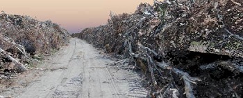 Debris volumes are measured using drones, and the data are used to develop an information-based model to determine cleanup cost. Source: Texas Tech Universityvolume of debris in that region, then fly a different region and estimate the volume of debris in that region,” said Joseph Dannemiller, an instructor in the Edward E. Whitacre Jr. College of Engineering and a doctoral candidate in the National Wind Institute. “Then, the industries that have grown up and now specialize in recovery could, through some central entity like the Federal Emergency Management Agency, be allocated to various disaster regions based on need. Right now, the decision of how assets are allocated is information-driven, but it is based on word of mouth or qualitative assessments.”
The researchers spent several days in the Texas Gulf Coast region after Hurricane Harvey, gathering aerial imagery and footage. The imagery, footage and ground assessment data were used to create an information-based approach to determine the cost of debris removal.
While they can’t cover as large a region as manned aircraft, the use of which incurs significant cost, drones can make more flights in the same time using photography equipment that provides more accurate assessments than imagery provided from conventional aircraft. Drones can also fly under any cloud cover that obstructs regions being photographed during manned flights, and take time-lapse measurements to assess how quickly and efficiently debris is being removed and how quickly a region can recover after a month, six months, a year or longer.
The model will also help determine how many homes and businesses were affected, how much deforestation occurred and how much infrastructure was damaged. The ability of drones to take pictures at various angles provides a 3D perspective and generates more information than that derived from traditional top-down pictures taken by manned aircraft. The analytical scheme will eventually be available for other natural events, such as tornadoes and wildfires.
The researchers are now developing a virtual reality environment using the same 3D models, which would allow people to walk around in a disaster region to understand the extent of the damage beyond just pictures and video from TV reports. A virtual reality model can be developed in about three days from a mapped area the size of the Texas Tech campus, for example.