These 6 Steps Could Protect Against Future Hurricane Flooding
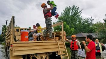
David Wagman | August 20, 2018A year after Hurricane Harvey inundated parts of Texas with as much as 60 inches of rain, the Texas Section of the American Society of Civil Engineers released a report that details steps the state should take to mitigate the impact of future flood events.
Hurricane Harvey made landfall as a category four hurricane near Rockport, Texas on Aug. 25, 2017, and impacted more than 40 counties in the state. At the time, it was the costliest natural disaster in Texas history, and the second most costly natural disaster in U.S. history, behind only Hurricane Katrina.
 Flooding impacted 40 counties across Texas in August 2017.Prior to the storm, ASCE gave the state’s overall flood control infrastructure a “D” in its 2017 Report Card for Texas's Infrastructure. (The state's infrastructure overall rated a grade of "C-.")To improve this grade, civil engineers made several recommendations to lawmakers and the public, including increasing funding for flood control infrastructure, flood warning systems, flood risk mapping, and enhancing state involvement in these programs.
Those recommendations are echoed in the latest report, "Addressing Flood Risk: A Path Forward for Texas After Hurricane Harvey." Among the recommendations:
Develop a Statewide Flood Mitigation Plan: The report calls on the Texas Water Development Board to develop and regularly update a statewide flood mitigation plan, with input from all levels of government, citizens, and the private sector. The state legislature, in partnership with localities and the federal government, should provide funding to support projects identified in the plan. The report says that for every $1 invested in mitigation, $6 is returned, according to the National Institute of Building Sciences.
(Read "Houston Mayor Now Likes an Ike Dike.")
Fund Dam Safety: The state should provide additional funding for Texas’s Dam Safety Program as well as a funding program for dam improvements. According to the ASCE report, a 2008 Audit Report found that, “[The Texas Commission on Environmental Quality’s] dam safety program, as currently designed and operating, is not able to accomplish its statutory mandate to ensure the safe construction, maintenance, repair, and removal of dams in the State of Texas.” Increased funding is necessary for this important program, ASCE says. Additionally, grants and loans designed to assist owners with dam repair, abandonment, or removal should be provided, either through the Dam Safety Program or another administrative process.
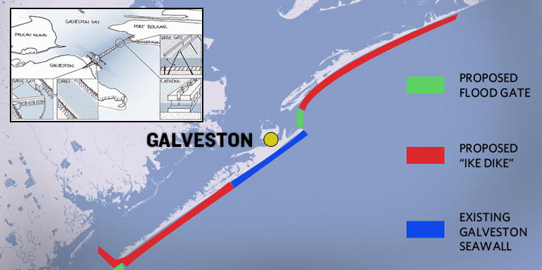 (Click to enlarge.) Diagram of proposed "Ike Dike" to help protect parts of the Gulf Coast from catastrophic flooding. Implement a Statewide Levee Safety Program: The Texas Commission on Environmental Quality should develop and implement a program for inventorying the condition of all levees in Texas. Levees are owned by a variety of local, regional and federal agencies, but the inspection of non-federal levees is not widely available, and their condition is often unknown, the ASCE report says. The state legislature, in partnership with the federal government, should establish a program to ensure the safe construction, maintenance and repair of levees in Texas.
(Read "Flood-Prone Houston's Drainage Grid Is 'Obsolete.'")
Focus on a Watershed Approach: Communities should take a watershed approach to flood risk management, the report says. Communities within each Texas watershed should coordinate their flood risk management regulations and infrastructure plans so that upstream activities don’t adversely impact downstream property owners and localities. Coordinated activities should also be used to plan and implement flood risk reduction programs and projects that help reduce flood risks for everyone within a watershed, not just those living in one community.
Neighboring watersheds should work together to create regional planning groups, which in turn could be integrated to create a statewide flood mitigation plan. ASCE says that such a structure would be similar to the existing state water planning framework, which includes 16 regional planning groups. Additionally, the state should establish minimum flood risk management standards and give all local jurisdictions sufficient authority to implement locally appropriate land development and floodplain management regulations.
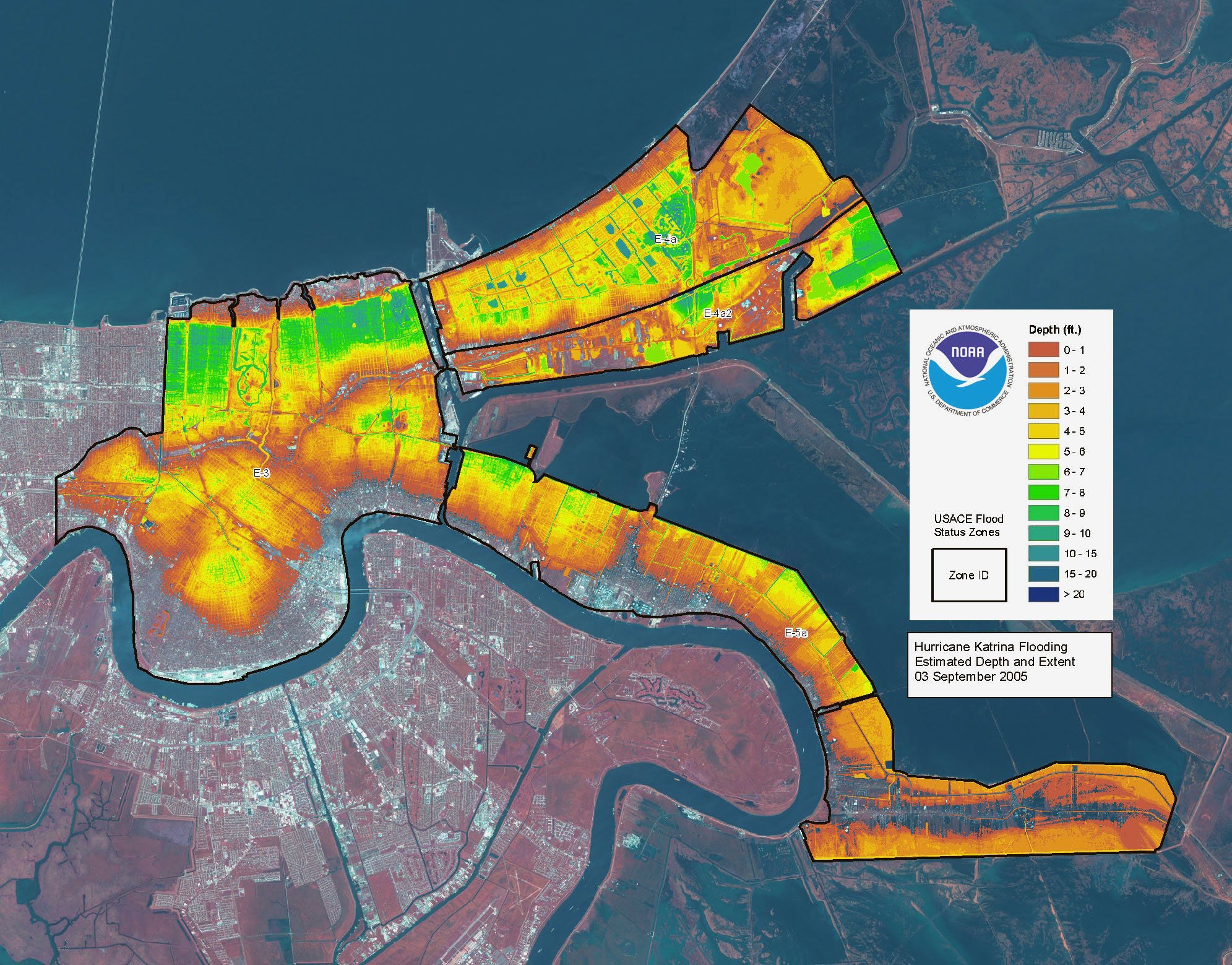 (Click to enlarge.) Map showing areas of flooding in New Orleans in the aftermath of Hurricane Katrina in 2005. Educate Citizens About Risk: Entities with authority over floodplain management should collaborate to implement a public outreach program to educate the Texas population about flood risk management and preparedness, including the roles of public agencies during emergency conditions. Increased education will help better inform residents about the watershed they live in, what infrastructure may affect their homes, and where to look for information during an emergency. Additionally, more robust flood risk maps that identify multiple risk levels, not just the boundary between areas with greater than a one percent annual chance of flooding and those with less, are needed. Risk maps should also show risks from other types of inundation, not just riverine flooding.
(Read "Lessons from French Engineers as Houston's Recovery Begins.")
Employ Alternative Flood Mitigation Strategies: The ASCE report says that the state should continue to invest in the development and deployment of alternative flood mitigation strategies, including green stormwater infrastructure (also known as “low impact development”). Technological advancements in permeable pavement, green roofs, and small-scale sedimentation and filtration ponds, as well as the installation of rain gardens, vegetated swales, and disconnecting flow paths can be effective tools to reduce flood risk and increase resiliency when implemented on a watershed basis. The natural environment should also be considered as an asset for flood risk management purposes, the report says.


Or . . . . move out of the flood zones. But that doesn't employ nearly as many civil engineers.
In reply to #1
Moving significant numbers out of flood zones would be a formidable task...especially getting everyone out of flood zones 'x' and 'o'. It could involve huge demand for civil engineers.
In reply to #2
Well, if 'we' stop enabling people to live in risky areas, they would move out on their own accord as it becomes economically unfeasible to continue living there. Having a National Flood Insurance program just perpetuates the problem. You know what they say about good intentions . . . .
In reply to #3
I am in full agreement with you about eliminating subsidiies for things like that.
I was just having a little fun in an attempt to point out that most people (in the US at least) reside in a flood zone. It is high risk flood zones that are the problem.
In reply to #4
Yeah, I was just having fun too, poking at the authors of the study. It's like asking a surgeon whether to cut or go to physical therapy.