Texas Coast Protection Could Cost $31b
David Wagman | October 31, 2018A draft plan costing upwards of $31 billion and intended in part to protect the Texas Gulf Coast from storm surges was released by the Texas General Land Office (GLO) and the United States Army Corps of Engineers (USACE).
Work on the Coastal Texas Protection and Restoration Study Draft Integrated Feasibility Report and Environmental Impact Statement began in 2015 and is intended to develop risk reduction options to address storm risks to the Texas coastline.
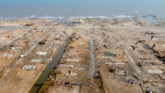 Damage along the Texas coast following Hurricane Ike in 2008. Source: Air Force photo / SMSgt Elizabeth GilbertThe draft environmental impact statement includes a plan that uses a "multiple lines of defense" strategy to reduce risks to communities and infrastructure. The plan includes building surge gates to reduce coastal storm damage risks to the Houston Ship Channel, levees along Bolivar Peninsula and Galveston Island, beach and dune replenishment along the lower coast, and nine landscape-scale ecosystem restoration projects to increase resilience and reduce risks to the coast. The estimated cost is $23 to $31 billion.
According to the report, one in every four Texans lives in the state's coastal area. Around 30% of the U.S. oil refining sector is located in the region. And the Port of Houston and the Port of Beaumont are the second and fourth busiest ports in the United States with around 428 million tons of cargo passing through the region each year. The Port of Beaumont handles more military cargo than any other U.S. port.
The study area for the Coastal Texas Study consists of the entire Texas Gulf Coast from the mouth of the Sabine River to the mouth of the Rio Grande, and includes the Gulf and tidal waters, barrier islands, estuaries, coastal wetlands, rivers and streams, and adjacent areas. (Read "These 6 Steps Could Protect Against Future Hurricane Flooding.")
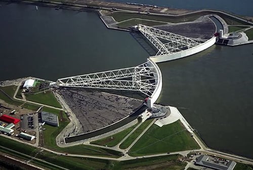 The structure would have an 800-foot opening for ship traffic that could be closed during a storm. On each side of the opening, a gate on a ball and socket would swing together to close. Source: Texas A&M FoundationFlood Walls and Barrier Gates
The preferred risk reduction system would include floodwalls (inverted T-walls), floodgates (both highway and railroad floodgates), seawall improvements, drainage structures, pump stations and surge barrier gates.
The largest feature would be at Bolivar Roads between Bolivar Peninsula and Galveston Island, which includes surge barrier gates that are made up of navigable floating sector gates and environmental lift gates, and a combi-wall made up of vertically driven piles with a battered support pile and a reinforced concrete cap.
Ike Dike
The protection project is known as the Ike Dike, named after Hurricane Ike, which caused around $30 billion in storm surge damage in September 2008. The Ike Dike project was conceived by professor Bill Merrell of Texas A&M University at Galveston, and received renewed interest after Hurricane Harvey deluged the region with rain in 2017.
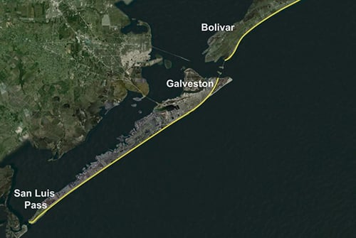 Map of proposed surge defenses near the ports of Galveston and Houston. Source: Texas A&M FoundationHurricane Harvey made landfall as a category four hurricane near Rockport, Texas, on Aug. 25, 2017, and impacted more than 40 counties in the state. At the time, it was the costliest natural disaster in Texas history, and the second most costly natural disaster in U.S. history, behind only Hurricane Katrina.
Prior to the storm, the American Society of Civil Engineers (ASCE) gave the state’s overall flood control infrastructure a “D” in its 2017 Report Card for Texas's Infrastructure. (The state's infrastructure overall rated a grade of "C-.") To improve this grade, the ASCE recommended an increase in funding for flood control infrastructure, the addition of flood warning systems, the preparation of flood risk mapping and enhanced state involvement in flood mitigation programs.
The latest coastal storm surge mitigation study builds on the work of scientists, engineers, and other experts from Rice University’s Severe Storm Prediction and Evacuation from Disasters (SSPEED) Center, Texas A&M University Galveston (TAMUG) and Gulf Coast Community Protection and Recovery District (GCCPRD).
The final feasibility report and environmental impact statement is expected in 2021. Project backers then would seek federal funding for the project.


Wouldn't it be cheaper to move?