How Does Land Surveying Work?
Shawn Martin | December 13, 2017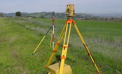 Source: Aavaaz home builder / CC BY-SA 4.0Land surveyors define boundary lines and establish land maps by determining the terrestrial or three-dimensional position of points and the distances and angles between them. They are able to eliminate accumulated errors and depict boundary lines with unprecedented accuracy by using standard operating principles. There are two basic surveying methods and the method used is dictated by the size of the area to be defined.
Types of Surveys
There are two broad types of land surveys carried out, geodetic surveys and plane surveys.
Plane surveys are carried out based on two basic principles. Points of interest are defined by object triangulation while measurements are made from whole to part. Two or more control points whose location has been defined with a high degree of precision are used to define a baseline. In order to eliminate accumulated errors, subsequent measurements are then made in reference to the established baseline. Plane surveys only suffice for mapping areas up to 250 square kilometers as there is no correction for earth’s curvature.
Geodetic surveys are required for surveyed areas greater than 250 square kilometers where corrections are required to account for earth’s curvature. Remote sensing techniques are used to define benchmarks, sometimes referred to as a ground control point. They are defined by their latitude, longitude and elevation. Points of interest in a geodetic survey are then defined by their angular position and arc length from these defined control points and are most commonly made using global positioning satellite (GPS) data.
The increased availability of high-accuracy satellite data has made for dramatic improvements in remote sensing. Valuable reference data including the geodetic datum of the United States, NAD83, which defines the geometric relationship between points in three-dimensional space, is available in electronic format.
Geodetic surveys are completed using high-accuracy global navigation satellite system (GNSS) data. Raw data files supplied by GNSS are filtered to help compensate for oblique measurements and atmospheric interference. Users are then able to use continuously operating reference stations (CORS) to correlate control points and greatly improve the precision of their measurements. Post-processing coordinates can be made within a few centimeters of the national spatial reference system (NSRS).
Governance
The National Geodetic Survey (NGS) is a federal agency that maintains the national coordinate system known as the NSRS. They maintain a network of over 2,000 CORS and provide surveyors with the required reference data to perform land surveys.
Instrumentation
Plane surveys require a device that can measure both linear distances and angular position with great precision. The conventional tool used is a theodolite, also known as a transit. The device consists of a movable telescope mounted within two perpendicular axes; the horizontal or trunnion axis, and the vertical axis.
The modern replacement for a theodolite is what is referred to as a total station. It is essentially a digital theodolite with an integrated electronic distance measuring (EDM) device that measures the distance from the instrument to its target. It also features an onboard computer with the capability of performing advanced coordinate-based calculations.
Conclusion
Legal authorities typically require licensed land surveyors to prepare boundary surveys. They are essential in defining physical assets, identifying potential encroachments and identifying easements. They can also mark the corners of a site and prepare a FEMA Elevation Certificate.
Resources:
National Geodetic Survey – Land Surveying
What is Land Survey | Define Survey, Plane & Geodetic Surveying


