Mapping Certified Forests for Sustainable Management
S. Himmelstein | June 28, 2017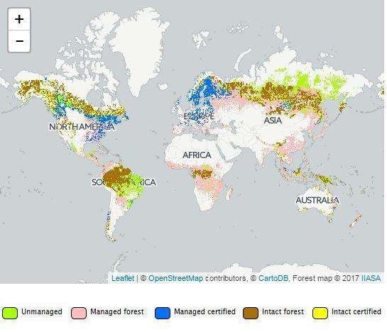 (© GeoWiki | IIASA)Certification is an approach to the sustainable exploitation of forest resources. Globally, about 10% of the total forest area had been certified by mid-2014, providing some transparency on the origin and management of these areas.
As information on spatial distribution of certified forest has been limited, a global map was recently developed by researchers at the International Institute for Applied Systems Analysis (IIASA) together with the Mercator Research Institute on Global Commons and Climate Change (MCC) and the Norwegian University of Life Sciences (NMBU). The map depicts certified forest areas at 1 kilometer resolution.
The new map combines country-level statistics with modern remote sensing products and crowdsourcing. This high resolution approach—for the first time applied to forest certification and sustainability—allows a large range of users including policymakers, non-governmental organizations, researchers, forest organizations, private investors and the general public to zoom in to an area of interest. It also provides a significant step forward in consumer transparency and credibility.
Combining primary forest and protected area data with information on certified and managed forests into one map contributes insight into the possible impact of certification to combat illegal deforestation and halt forest degradation.
To support data validation, the researchers used the interactive online crowdsourcing platform Geo-Wiki as a participatory and collaborative mapping tool in which users can give feedback to improve the map. The new certification map is also openly accessible on the platform.