Radar sees the forest through the trees
S. Himmelstein | December 22, 2023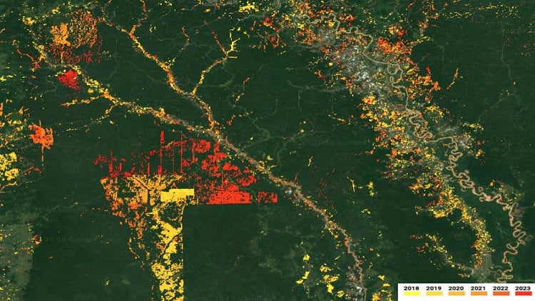 LUCA data reflect forest disturbance from small-scale agriculture and industrial agroforestry expansion in Kalimantan, Indonesia, for the 2018 to 2023 period. Source: CTrees
Resource and conservation managers can now use a radar-based eye in the sky to monitor the status of forest coverage and health worldwide. The Land Use Change Alert (LUCA) system launched by non-profit organization CTrees is a forest disturbance alert system that provides near-real-time information on forests globally.
The LUCA platform leverages data from the European Space Agency’s Sentinel-1 C-band synthetic aperture radar (SAR) imagery, which generates high-resolution images of the global land surface under almost all-weather conditions every 6 to 12 days. Analysis of this imagery enables detection of changes in land cover almost at the time that it occurs for areas with a minimum of 15% tree cover and average tree height of 5 m.
State-of-the-art machine learning techniques are applied to detect forest loss at a minimum mapping unit of 0.05 hectares from deforestation, degradation, fire and other disturbances. Alerts documenting the location and extent of such changes are issued every two weeks.
Future iterations of LUCA will integrate more satellite data sources, such as L-band radar imagery from the NASA-ISRO SAR mission to be launched in early 2024. The expanded features will include coverage of areas outside of forests, more frequent alerts and land use change attributions.