Seismic Imaging Helps BP Spot Additional Oil Reserves
David Wagman | April 28, 2017BP says that it used seismic imaging to identify more than 200 million barrels of additional resources at its Atlantis field in the deepwater Gulf of Mexico.
As a result, BP says it will deploy this technique to fields elsewhere in the Gulf of Mexico as well as in Azerbaijan, Angola, and Trinidad and Tobago.
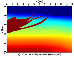 Image of the formation in 2004. Credit: BPThe innovation has enabled BP to enhance the clarity of images that it collects during seismic surveys, particularly areas below the earth’s surface that complex salt structures previously obscured or distorted. The sharper seismic images mean that BP can drill new development wells in deepwater reservoirs with higher confidence and accuracy.
(Watch a BP video of the seismic imaging technology.)
Proprietary algorithms developed by BP’s Subsurface Technical Center were applied on seismic data run at BP’s Center for High Performance Computing, one of the largest supercomputers in the world dedicated to commercial research. The algorithms allowed data that would normally take a year to be analyzed to be processed in a few weeks, accelerating BP’s development decisions for the field.
 Image of the formation in 2016, using the seismic technique.The algorithms enhance a technique known as Full Waveform Inversion (FWI), which matches seismic simulations with existing seismic data to produce high quality subsurface images. FWI iteratively refines models of the subsurface by generating seismic wave simulations and adjusting the values of subsurface properties based on the quality of the match between the simulated and recorded data.
The subsurface property models that are created by FWI are used to create high-quality and high-resolution images of oil and gas reservoirs.
BP’s Center for High Performance Computing is located in Houston and opened in 2013. It enables BP to do complex modeling of the geological formations below the surface, develop advanced algorithms to improve the understanding of hydrocarbon-bearing reservoirs, and to advance new acquisition technologies and survey designs that help see the subsurface more clearly.


Wonderful. Those irresponsible bastards should be kept away from the GoM as far possible.