When seconds count: Engineering infrastructure to weather the storm
Cari Cooney | July 14, 2025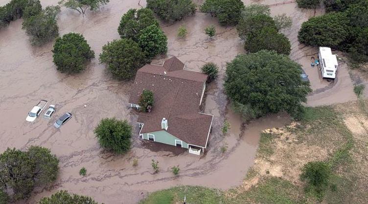 Flash flooding devastated several Texas communities in 2025. Image: USCG
In July of 2025, flash flooding devastated several communities in the state of Texas. In a matter of minutes, people were hit with rapid, dark, deadly waters…with some initial reports stating almost 30 feet of water in places. With so much water so quickly, many were faced with the option to simply survive.
Communities now mourn the monumental loss of lives and property. With so much rebuilding to do in the future, what precautions and protocols do civil engineering professionals take into consideration when designing infrastructure? There is an abundance of historical data to show flooding locations, but what about other serious weather events? Regardless of personal opinions about climate change: climate does indeed change. Weather patterns ebb and flow, 100-year floods are often more frequent and wildfires will always exist.
[Why did the ASCE give the US a 'C' for infrastructure in 2025? Read about it on GlobalSpec]
Historical weather data is just one (and not proving as accurate as time goes by) tool engineers reference when looking at future infrastructure projects. When yesterday’s records no longer reflect the threats of tomorrow, how should civil engineers strategize for extremes?
Flood hotspots
Previous data is a key factor in determining flood plains, but plate shifting, soil excavation and community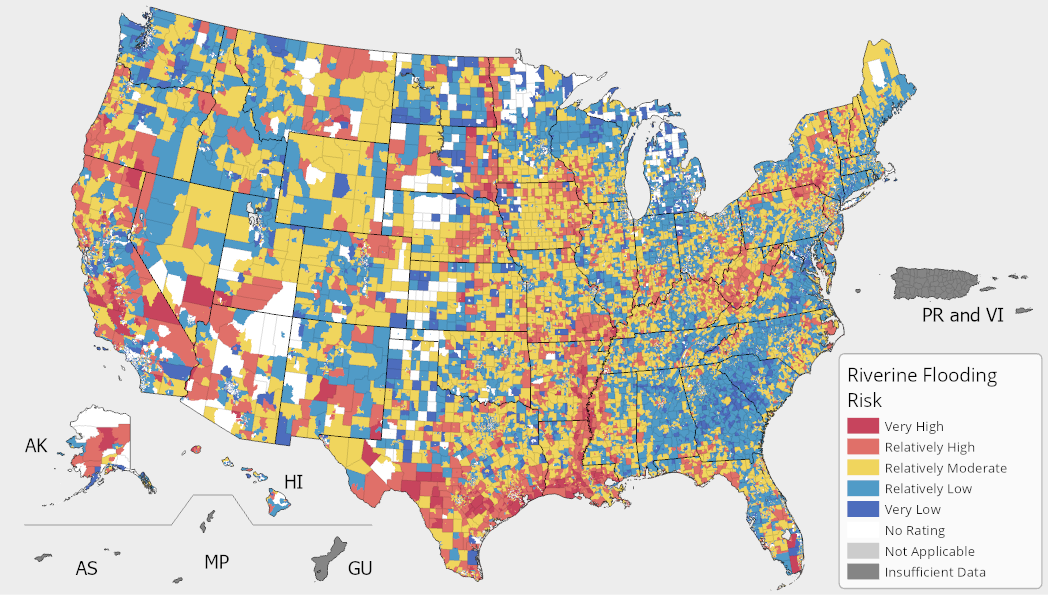 Many argue the flood maps are outdated and inaccurate. Image: U.S. Federal Emergency Management Agency development continue to evolve, changing the analytics in real time.
A standard way engineers size up flood risk is by observing something called the “design flood” — think of it as the worst-case downpour you can reasonably visualize. In the U.S., they’ll often use the Probable Maximum Flood, defined in 40 CFR §257.53 as the biggest surge you’d expect from the toughest combination of weather and watershed conditions that could believably occur.
Resilient design is the first line of protection against natural disasters. A new standard now helps equip buildings to withstand the powerful destruction a flood can unleash. ASCE/SEI 24-24 — Flood Resistant Design and Construction — lays out the essential rules for construction in flood-prone zones. It covers everything from the minimum construction standards and accepted materials for flood‐resistant structures to the requirements of the National Flood Insurance Program and so on.
Stationary isn’t an option
Structural engineering professionals understand that the earth is a living, shifting thing. Building at higher levels than previous years is one standard that helps keep structures from experiencing a water crisis, but that is one very small piece of the safe infrastructure puzzle. A possible next step is perhaps to tweak those old-school flood-design formulas, so they match today’s reality — basically amending them with fresh, real-world numbers instead of assuming the climate stays on repeat. Data needs to be constantly updated to take realistic approaches for safer structural projects.
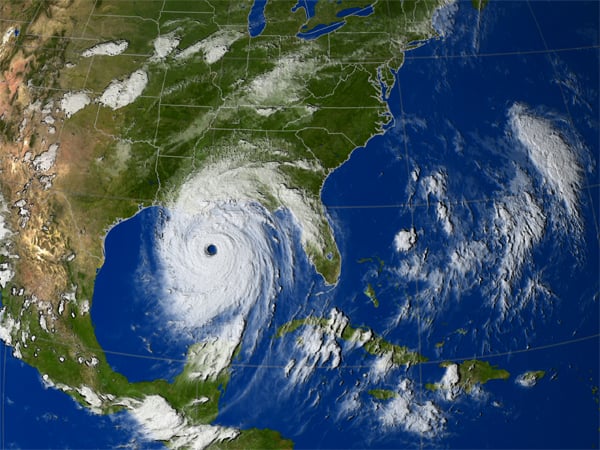 In 2005, Hurricane Katrina, the most destructive natural disaster in US history, reached the shore. Image source: NASAThis isn’t just the thought process for future designs; this applies when current infrastructure needs to be modified. This task can be very difficult. A completed, functioning levee is a good example of something that cannot easily be altered. While it might seem simple enough to just add height to the structure, it also requires more width to support it.
A look back at 2017’s Hurricane Katrina
After Katrina, New Orleans’ new storm risk reduction system swapped out “worst-case” guessing for renewed probability analyses, building in extra conservatism by evaluating a variety of flood scenarios. Regrettably, Congress insisted on the 100-year-flood as the baseline proposal, capping the system’s flexibility and making it harder to adapt to situations the future might throw our way.
What is one of the most deadly and destructive parts of a storm? The surge. Quick-rising, hard-hitting water levels continue to be a concern when planning or updating infrastructure. Flood walls, impact-absorbing building materials, proper drainage systems, and erosion control are all important (but not a complete list of) details professionals look at during the design process. It’s important to note that it’s not always possible to mitigate the danger; the goal is often to mitigate the destruction instead.
A storm on the horizon meets predictive design
Gilbert White was the Gustavson Distinguished Professor Emeritus of Geography at the University of The AquaFence got global recognition for protecting the Tampa hospital from the 2024 hurricane. Image source: AquaFence Colorado from 1980 until 2006. He was also Director of the university's Natural Hazards Research and Applications Information Center (now named the "Natural Hazards Center") through 1994.
He’s known for saying, “Floods are ‘acts of God,’ but flood losses are largely acts of man.” These wise words come in handy when remembering that while accurate predictions of weather aren’t always a reality, a focus on the errors previously made in infrastructures that failed could lead to a better outcome. There is no one single government agency or program dedicated to smart storm/water regulations, and there are always so many variables to consider; a hazard of the trade to civil and structural engineers.
When NOAA launched the Office of Water Prediction and the National Water Center in 2015, it set off a push to progress national water models, enhance the quality, speed, and precision of those forecasts. Its goal was to assist in accelerate useful research to combat the 100-year flood baseline that most infrastructure professionals feel is archaic, but the government sees as relevant.
Civil engineers of the present and future must be key players in every step of the infrastructure design process, with access to all land and weather data to put their skills to best use. Weather-safe buildings will no doubt always have a combination of old and new practices, learning from previous analytics and growing with future technologies.
Watch the video below to see an innovative, flexible flood wall in action.
The ASCE-National Oceanic and Atmospheric Administration Task Force on Climate Resilience in Engineering Practice is in place for engineering professionals to collaborate on bridging the gaps between climate data and smart engineering to achieve the highest hazard reduction possible in infrastructure planning.


