Watch: Use your computer to help NASA drive its Mars rovers
S. Himmelstein | June 18, 2020Equipped with computers, time and a desire to improve the driving skills of others, citizen scientists can help NASA's Curiosity rover better navigate Mars. Volunteers are needed to label terrain in images taken by rovers and train an artificial intelligence algorithm to automatically read the landscape.
Rover driving plans are now executed virtually and require many scientists to write and review hundreds of lines of code at a high time cost. Terrain must be analyzed and travel routes selected to prevent Curiosity from 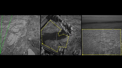 Images from AI4Mars show different kinds of Martian terrain as seen by NASA's Curiosity rover. Draw borders around terrain features and assign labels to them to help train an algorithm that will automatically identify terrain types for rover planners. Source: NASA/Jet Propulsion Laboratory-Caltechgetting bogged down in sand or damaged by rough surfaces. By using the AI4Mars online tool, citizen scientists can help by drawing boundaries around and labeling terrain features. These contributions will enhance the ability of the Soil Property and Object Classification (SPOC) algorithm to identify terrain types and generate mission maps.
Improvements to SPOC will logically free up rover planners to focus on other tasks, such as determining the orientation of the craft at the end of a drive to provide its high-gain antenna a clear line of sight to Earth to receive commands. Evaluation of the more than 8,000 Curiosity images uploaded to date will result in an archive of labeled images of use to future Mars missions, including the Perseverance rover mission planned for this summer.