These Hydro Dams Could Fall Under $400M Proposal
David Wagman | August 10, 2018Federal officials are reviewing a nearly $400 million plan to remove hydroelectric dams along the Klamath River in California and Oregon.
The power stations have a combined generating capacity of around 150 megawatts. Their removal would reestablish a free-flowing river to a stretch of the Klamath River around 200 miles from the Pacific Ocean.
 (Click to enlarge.) Map showing location of dams to be removed. Credit: KRRCThe dams and associated power production equipment were installed between 1902 and 1962. The facilities are owned by PacifiCorp and include the J.C. Boyle hydro station (98 MW), COPCO 1 (20 MW), COPCO 2 (27 MW), Iron Gate (18 MW), Fall Creek (2.2 MW), Eastside (3.2 MW), and Westside (0.6 MW).
In September 2016, PacifiCorp and the Klamath River Renewal Corp.(KRCC) asked the Federal Energy Regulatory Commission (FERC) to transfer ownership of the hydro assets to the KRRC. FERC has licensing authority over hydroelectric facilities and will review the proposal to remove the dams and associated equipment.
The utility says that environmentalists, Native American tribes, and commercial fishermen have long urged that the dams be removed and that additional water be made available for fish. Likewise, farmers have sought more reliable water supplies to support irrigated agriculture.
In 2000, the utility began the process to relicense the power plants with the FERC. In February 2010, more than 40 other signatories executed the Klamath Hydroelectric Settlement Agreement (KHSA), which provides a framework for the potential removal of the dams in 2020.
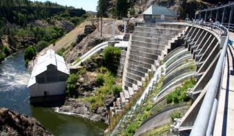 Copco 1 dam and powerhouse would be removed under the proposal before FERC. Under terms of the agreement, four dams would be removed -- J.C. Boyle, Copco 1 and 2 and Iron Gate. The Klamath developments have a total of 12 turbine-generators, five limited-storage reservoirs and five concrete or earth/rock fill dams.
The project’s five reservoirs range in size from 40 to about 1,000 surface acres. The 173-foot-tall earth and rockfill dam associated with the Iron Gate project is the tallest dam and forms the 944-acre Iron Gate Reservoir. As the last development in the string of PacifiCorp’s Klamath hydroelectric facilities, Iron Gate serves as a re-regulation facility for river flows downstream of the project.
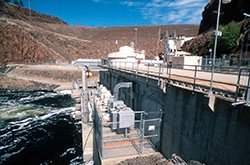 An unidentified dam along the Klamath River. Credit: PacifiCorpPacifiCorp maintains 20 recreation sites associated with the Klamath project. The facilities include campgrounds, boat ramps, trails and picnic, fishing and swimming areas.
The removal proposal that was submitted to FERC envisions removing the four dam developments in order to achieve a free-flowing river and fish passage. The project also includes site remediation and restoration, including land that had been under way, and steps to avoid or minimize adverse downstream impacts.
The plan describes two different options. Full removal would completely remove the dams, power generation facilities, water intake structures, canals, pipelines and ancillary buildings. Partial removal would retain portions of each dam, along with ancillary buildings and structures such as powerhouses, foundations, tunnels and pipes. This scaled down proposal still would achieve the project goal of achieving a free-flowing river and fish passage.
Before removing the hydropower developments, water surface elevations in each reservoir would be drawn down as low as possible to make it easier to remove accumulated sediment and to create a dry work area for various removal activities. Water drawdown would begin around Jan. 1, 2021, and would extend through March 15 of that year.
Once the drawdown was complete, any remaining reservoir sediments would be stabilized and dam and hydropower development removal would begin.
Full reservoir area restoration would also start after drawdown, and continue through 2021 and perhaps into 2022. Vegetation re-establishment could take several years.
Other key project components include measures to reduce project-related effects to aquatic and terrestrial resources, road and bridge improvements, relocation of the City of Yreka’s pipeline across Iron Gate Reservoir and associated diversion facility improvements, demolition of various recreation facilities adjacent to the reservoirs, recreation improvements, downstream flood control improvements, groundwater system improvements, water supply improvements, fish hatchery modification and improvements and measures to protect identified historic, cultural and tribal resources.


