
Satellites Measure Earth Movement Down to the Millimeter
John Simpson | December 01, 2016Copernicus Sentinel-1 twin radar satellites, combined with cloud computing, are monitoring Europe’s earthquake zones by searching for ground shifts as small as a millimeter.
The satellites, launched by the European Space Agency (ESA), take successive radar images of the same location, which are then combined to reveal the tiniest of shifts. Once any motion of interest has been identified, more detailed checks can be made through ESA's Geohazards Exploitation Platform (GEP).
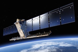 Sentinel-1 satellites take successive radar images of the same location, which are then combined to reveal any ground shifting. Image credit: ESA.The new automatic radar service monitoring Europe’s seismic regions covers an area of three million square kilometers in 200-meter blocks. The plan is to gradually scale up to cover the entire world’s tectonic regions, which adds up to a quarter of the Earth’s land surface.
According to ESA, the combined radar scans are sensitive to a greater level of detail than point-by-point GPS measurements. However, the process demands heavy computing power.
“The real step change here is that they are being produced across extended areas on an entirely automated basis,” says Fabrizio Pacini, manager of key accounts at cloud services provider Terradue, which oversees the GEP.
The service is processing an average of 50 image pairs per day across Europe from the Sentinel-1A and Sentinel-1B satellites, with six days between coverage. In 2017, this will increase to 130 pairs per day— with a maximum of 24 days and potentially 12 days between acquisitions outside Europe—involving the daily processing of 1 terabyte of data, with additional higher resolution produced on request.



Yepp, and then they find out that buildings are losing ground, sink and lose value and safety all at the same time.
http://www.techly.co
It would be interesting to see what they're also measuring in terms of Earth tides where the ground moves vertically as much as a metre or more under the gravitational influence of the Moon and Sun.