Computer Analysis Maps Hidden Freshwater Runoff
John Simpson | August 16, 2016A map of underground drainage systems that connect fresh groundwater sources and seawater has highlighted previously hidden sources of pollution along more than 20% of U.S. coastlines.
Scientists have long known that freshwater and seawater mix below ground, but they typically hadn’t been able to pinpoint where it was happening, except in limited locations. Together with partners at NASA’s Jet Propulsion Laboratory (JPL), Audrey Sawyer, assistant professor of earth sciences at The Ohio State University, used computer analysis to learn more about the water exchanges.
Sawyer, together with Cédric David and James Famiglietti of JPL, combined U.S. topography and climate models to identify inland regions that contribute groundwater and contaminants to the coast. They examined rainfall, evaporation rates and the amount of known surface runoff to calculate the missing portion of water that was running out below ground. They melded those results with terrain and land-use data to identify where the water ended up.
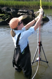 Audrey Sawyer of The Ohio State University tests water for contaminants. Image credit: OSU. The study identified 12% of the continental U.S. coastline—including the northern Gulf Coast from Mississippi to the Florida Panhandle, the northern Atlantic Coast and the Pacific Northwest—where hidden drainage systems make the ocean most susceptible to freshwater contamination from septic tanks and fertilizer runoff. There, excess nutrients in the water can cause harmful algal blooms and remove vital oxygen from the water. This contamination may endanger fisheries and coral reefs as well as water recreation and tourism.
A further 9% of coastline, including southeastern Florida, Southern California and Long Island in New York, is especially susceptible to contamination from sea to land, the study found. In those areas, saltwater intrudes inland and infiltrates fresh groundwater supplies.
Among the sites with the worst impacts are Los Angeles and San Francisco, which the study found to be vulnerable to both ocean contamination and saltwater intrusion.
Overall, more than 15 billion tons of freshwater flows through invisible underground networks into the ocean along the continental U.S. coastline every year, the researchers found. While that is less than 1% of the total amount that flows from the continental U.S. into the ocean (the rest comes from rivers and surface runoff) it tends to be particularly rich in nutrients and other contaminants.
According to the researchers, increased urbanization—and the extensive pavement that goes along with it—will decrease groundwater recharge and boost draining to coastal regions where the population is growing, which increases the likelihood of saltwater intrusion.