Transforming smartphone sensors into earthquake detectors
Marie Donlon | November 25, 2025Researchers from the University of Bergamo, Italy, GFZ Helmholtz Center for Geosciences, Germany, and the European-Mediterranean Seismological Center, France, have suggested that smartphones could one day be used to detect the vibrations of earthquakes.
Specifically, the team believes that smartphones could be used to develop highly detailed site amplification maps using the built-in accelerometers in smartphones.
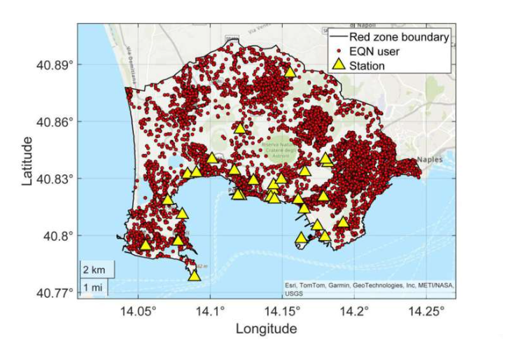 Source: CC BY-NC-ND 4.0, Finazzi et al. (2025); https://doi.org/10.1038/s41467-025-64543-3
To demonstrate, the team combined thousands of such measurements from the Italian Campi Flegrei region with statistical modeling, proving that it is possible to map how local geology amplifies shaking, achieving details beyond what seismic stations alone offer. The team believes that this information will offer crucial input for seismic hazard assessment as well as support earthquake emergency response.
This new approach builds on the Earthquake Network (EQN), which is a citizen science initiative launched in 2013 and that currently involves more than 20 million citizens using smartphones for real-time seismic monitoring and early warning. As an earthquake occurs, participating phones will detect the shaking and send signals to a central server. Seconds later, alerts are issued to users in nearby areas, giving participants time before the shaking reaches them.
Building upon this, the team created a spatial statistical model that filters out building and device effects from smartphone data to reveal true ground-shaking patterns. By combining thousands of smartphone readings from the EQN smartphone network with traditional seismic data, they designed reliable, high-resolution amplification maps despite the noise in individual measurements.
"The EQN smartphone network is of high density and covers areas of the red zone where no stations are installed. This allows the variability of the ground shaking to be captured at a higher spatial resolution over the entire red zone," explained authors of the study.
Using historical smartphone data and new acceleration measurements, the team can create high-resolution “ShakeMaps” that demonstrate how strongly different areas shook during an earthquake. These maps are vital for analyzing impacts, planning emergency responses, guiding rescue teams and estimating damage.
"With urban populations growing worldwide and the urgent need for high-resolution ShakeMaps, this study shows that combining citizens' smartphone accelerometer data with seismic network observations enables the generation of site-specific, high-resolution ShakeMaps in densely populated urban areas. This improves the characterization of ground motion in the built environment, where seismic risk is concentrated," the researchers concluded.
The work is detailed in the article “Citizens' smartphones unravel earthquake shaking in urban areas,” which appears in the journal Nature Communications.