NASA, Northrop Grumman Make Advancements in Soil Moisture Data
Engineering360 News Desk | July 08, 2015NASA’s Soil Moisture Active Passive (SMAP) observatory has completed its commissioning phase, and is ready to start its three-year science mission.
SMAP will provide scientists with an accurate, frequent mapping of soil moisture levels all around the world by mapping the entire land surface of Earth every two to three 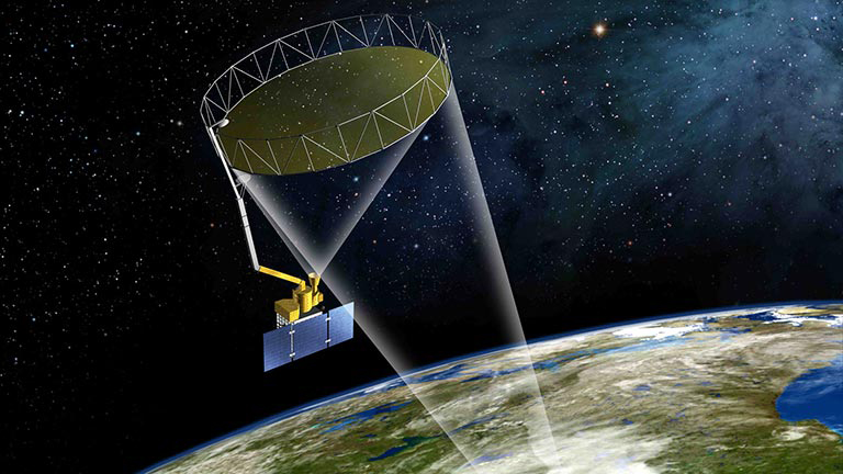 SMAP will provide scientists with an accurate, frequent mapping of soil moisture levels all around the world by mapping the entire land surface of Earth every two to three days. Source: NASAdays, according to NASA.
This information will help scientists better understand the links between Earth’s water, energy and carbon cycles, as well as improve drought monitoring and flood predictions.
“From current climate models that produce widely differing estimates of how much water will be available regionally in the future, to inaccurate local weather forecasts, the value of high-resolution measurements of soil moisture has been recognized for decades. Existing ground-based measurements are too sparse to show detailed variations,” says Dara Entekhabi of the Massachusetts Institute of Technology in Cambridge and SMAP’s Science Team leader, who has worked on the program since inception. “We knew that better data could have a hugely positive impact, but didn’t have the technology to make it work in a cost-effective way.”
SMAP was first launched from Vandenberg Air Force Base in California at the end of January 2015, and ground controllers completed all planned orbit deployments and spacecraft instrument checkouts by late April.
Once the commissioning phase was over, the solar array and reflector boom assembly, which contain SMAP’s 20-foot reflector antenna, were unfurled and deployed. The antenna and instruments were spun up to their full speed of roughly 15 revolutions per minute.
Now, NASA scientists are starting the calibration and validation process for SMAP, using the lowest level data products, such as maps of backscatter and brightness temperature.
Preliminary-level, or “beta” calibrated data will be available in August at designated public-access data archive. Preliminary soil moisture and freeze/thaw products will also be available in November, with validated measurements scheduled to be available for use by the general science community in the summer of 2016.
News Articles:
NASA, SpaceX Probe Rocket Launch Failure
NASA and DLR Partner to Develop Aircraft Noise Reduction Technologies
NASA Says Safety Systems Are Needed for Low-Altitude Airspace