Might Harvey Hasten the Ike Dike?
David Wagman | August 25, 2017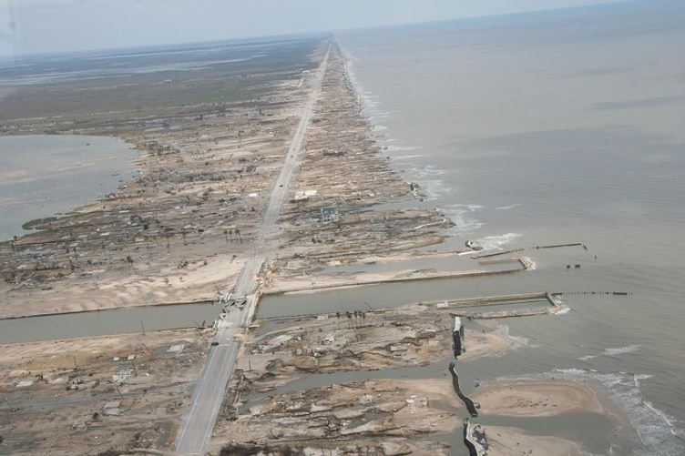 Damage caused by Hurricane Ike in the Bolivar Peninsula, Texas. Credit: Wikimedia Commons
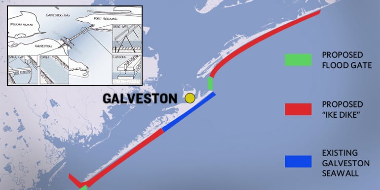 (Click to enlarge.) Concept for the Ike Dike. A key element of the concept is a movable flood barrier that can seal off the bay near Galveston and Houston during a hurricane.
Hurricane Harvey could renew interest in building a $15 billion coastal barrier designed to protect the Houston-Galveston region from hurricane storm surge.
The project, known as the Ike Dike, was named after Hurricane Ike, which caused extensive storm surge damage in September 2008. That storm caused around $30 billion in damage to areas in and around the Texas Gulf Coast, which is America's energy heartland.
The Ike Dike project was conceived by Professor Bill Merrell of Texas A&M University at Galveston. The project would extend protection afforded by the existing Galveston Seawall along the rest of Galveston Island and along the Bolivar Peninsula. It would include a 17-foot-high revetment near the beach and raising coastal highways.
The addition of flood gates at Bolivar Roads, the entrance to the Houston, Texas City and Galveston ship channels, and at San Luis pass would complete a barrier against Gulf surges into the Bay. Merrell argues that the Ike Dike could be built using existing technology such as the gates and barriers currently used in the Delta Works project located in the Netherlands.
In April, Texas General Land Office Commissioner George P. Bush sent President Trump a letter, cosigned by more than 60 state and local leaders, asking for $15 billion in federal money to fund the Ike Dike.
The Port of Houston and the Port of Beaumont are the second and fourth busiest ports in the United States with around 428 million tons of cargo passing through the region each year. The Port of Beaumont handles more military cargo than any other U.S. port.
Some environmental groups have opposed the project due to concerns over how the barrier might change salinity levels in the Bay, potentially affecting wildlife.
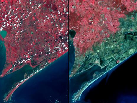 From the coast to over 15-km inland, salt water saturated the soil as a result of the 7-m storm surge pushed ashore by the force of the hurricane. The right image was acquired on September 28; the left image was acquired August 15, 2006. Vegetation is displayed in red, and inundated areas are in blue-green. Within the inundated area are several small "red islands" of high ground where salt domes raised the level of the land, and protected the vegetation. Source: NASA Jet Propulsion LabIn January, the Houston Chronicle reported that Rice University's Severe Storm Prediction Education and Evacuation from Disasters Center (SSPEED) designed a secondary defense system of gates and levees that would be built inside the bay, with another gate at the entrance to Clear Lake.
In a November 2016 report, the SSPEED team said it concluded that no single strategy would provide the level and scope of surge protection needed for the Houston-Galveston region. Instead, the team decided to advocate developing a strategy involving “multiple lines of defense,” a concept being followed in the Netherlands.
The U.S. Army Corps of Engineers also is devising a storm-surge protection plan for the entire Texas coast. Most of the studies are unlikely to be completed before the end of 2017, the paper said.
The Houston-Galveston area is responsible for more than half of the U.S. supply of jet fuel, is home to nearly one-third of its petroleum refining capacity and is the largest supplier of energy products to the military.
The area is home to the largest concentration of petroleum refining and petrochemical processing plants in the United States. A 2006 report by the Independence Insurance Agents of Texas estimated that a storm similar to Hurricane Katrina, which hit New Orleans in 2005, could disrupt $52.2 billion in gross Texas state product, $43.8 billion in personal income, affect 617,000 jobs and impact $1.8 billion a year in fiscal revenue.
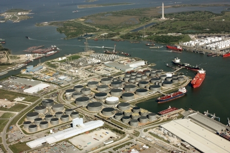 The Port of Houston and the Port of Beaumont are the second and fourth busiest ports in the United States with around 428 million tons of cargo passing through the region each year.Given the region's status as the country's energy heartland, the economic damage to the United States could also be serious.
In his April letter, Bush says that the coastal barrier would be built to a 100-year event standard. He said that models suggest it would have prevented 87 percent of Hurricane Ike's damage.
"Many scientists today believe that Hurricane Ike was a 'good miss,' meaning that we were fortunate that it did not cause more damage," Bush wrote. "That was nearly 10 years ago, and little has been done to protect the area's critical infrastructure."


