Saltwater Injection and Earthquake Mitigation in Oklahoma
S. Himmelstein | January 05, 2018A recent increase in the incidence of earthquakes in Oklahoma is largely attributed to the proliferation of salt-water disposal (SWD) wells associated with unconventional oil and gas recovery. A reduction in the volume of produced brackish water injected into the ground has lowered the number of small fluid-triggered earthquakes but has not mitigated the rate of bigger earthquakes events. Researchers from Virginia Polytechnic Institute and State University conducted a geospatial analysis of earthquake occurrence in the state and SWD volume to find out why.
Instead of linking SWD wells and seismic activity in time, the researchers examined that correlation spatially by assessing earthquake epicenters and SWD well locations. The study focused on the porous Arbuckle Group geologic formation in north-central Oklahoma where earthquakes originate in basement rock at a depth of 4 to 8 kilometers.
The researchers observed a narrowing of spatial occurrence when average annual well locations and earthquake epicenters were plotted. SWD volume and earthquake occurrence were fund to be spatially correlated up to 125 km. That's the distance within which there seems to be a connection between injection volume, fluid movement and earthquake occurrence.
The spatial correlation for smaller earthquakes weakened in 2016, when new regulations reduced pumping volumes but the spatial correlation for magnitude 3.0+ earthquakes persisted unabated. Two notable earthquakes shook the region in September 2016 and November 2016. The first, magnitude 5.8, was the largest ever recorded in Oklahoma. The second, magnitude 5.0, affected the area surrounding the nation's largest oil storage facility, containing millions of barrels of oil.
Why has reduced fluid pressure only affected small faults? Explains researcher Ryan M. Pollyea, “It's like the traffic on the freeway is still moving, but the smaller arterials are cut off.” They can't predict single earthquakes or even identify specific wells for specific events. But to reduce large fluid-triggered earthquakes, Pollyea concludes, “It appears that the way to do it is to inject less water.”
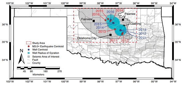 Annual geographic centroid locations for the years 2011-2016 (the underlying fault map is by Marsh and Holland, 2016), including volume-weighted well centroids, the 1σ radius of gyration, and M3+ earthquake centroids. Credit: Pollyea et al. and the journal Geology