Drones Team with Biobots Map Areas After Disasters
Engineering360 News Desk | November 23, 2016Researchers at North Carolina State University have developed a combination of software and hardware that will allow them to use unmanned aerial vehicles (UAVs) and insect cyborgs, or biobots, to map areas such as collapsed buildings after a disaster.
The biobots will be equipped with sensors and sent into these unmapped areas. But their movements will be restricted so that they are only able to explore a predefined area. For instance, their movements may be restricted to 20 meters from the UAVs.
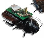 Image credit: Edgar LobatonThe biobots would signal researchers via radio waves whenever they got close to each other. Software would then use an algorithm to translate the biobot sensor data into a map of the environment.
Once the program receives enough data to map the defined area, the UAV moves forward to hover over an adjacent, unexplored section. The biobots move with it, and the mapping process is repeated. The software program then stitches the new map to the previous one. This can be repeated until the entire region or structure has been mapped; that map could then be used by first responders or other authorities.
Co-lead author Alper Bozkurt, an associate professor of electrical and computer engineering at NC State, has previously developed functional cockroach biobots. However, to test the new mapping technology, the research team relied on inch-and-a-half-long robots that simulate cockroach behavior.
In their experiment, researchers released these robots into a maze-like space, with the effect of the UAV beacon emulated using an overhead camera and a physical boundary attached to a moving cart. The cart was moved as the robots mapped the area.