Recipe for a thunderstorm
Ryan Clancy | June 25, 2021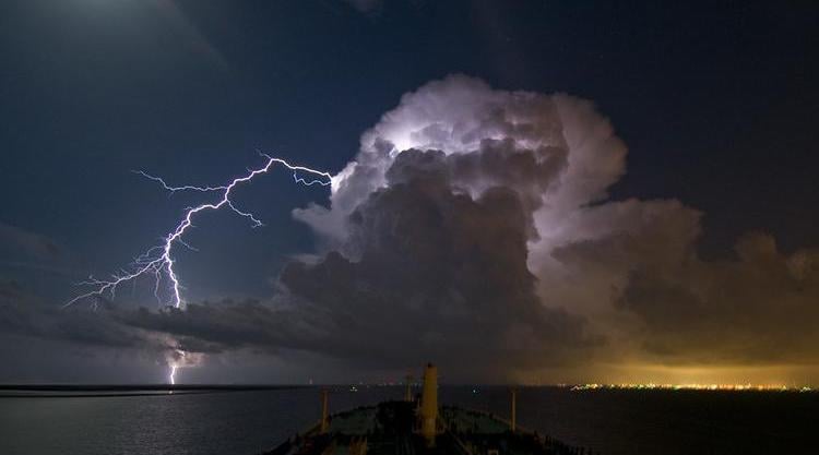 Source: Louis Vest/CC BY-NC 2.0
Thunderstorms are most common during the spring and summer, as generally the atmosphere is carrying more humidity - an essential ingredient for any lightning show. Yes, thundersnow occurs, but it is much more rare, and fundamentally, not any different than a summer thunderstorm.
Atmosphere moisture comes from nearby bodies of water, like the Gulf of Mexico, Pacific and Atlantic oceans. Large lakes can have contribute as well. Regions that are nearer to a warmer supply of water have much more moisture in the air, as evaporation occurs more readily. in warmer water.
So, humidity, and what else?
(Learn about humidity measurement on GlobalSpec.)
Unstable air that rises
The concept of unstable air is that if a bubble or “parcel” of air moves upwards, that air will not stop and will keep going up. A mass of unstable air has warm, moist air right at the surface, and dry, cold air higher up. When there is an unstable atmosphere, many of these bubbles or “parcels” of air get pushed up, which result in them cooling down. The moisture in the air condenses as it cools down, and a cumulonimbus cloud is formed from this. This is what drives the thunderstorms.
A lifting mechanism
So air must move upwards, but how does it get pushed vertically? Air cannot move by itself, so it must be pushed, and this is where the lifting mechanism comes in. There are any forms of lifting mechanisms, any of which can create the necessary effect. To understand this phenomenon, one must have a basic understanding of differential heating. This is where you have warm air next to cold air right at the surface, the cold air will pulled downwards because of gravity, and the warm air will rise, creating circulation. This circulation transports moisture upwards. Lets go through the various types of lifting mechanisms that can occur.
Fronts
The boundary where two different air masses meet is referred to as a front. When a cold front meets a warm front, the cold air cuts under the warm air and pushes it upwards. The air that rises will bring moisture with it. Simple enough.
name="_Hlk74258334">
Lake Breeze
Another common situation is where a lake breeze brings a wave of much cooler air with it. This meets the significantly warmer air on land and creates a similar effect to an outflow boundary or cold front. The cold air will carry a lot of moisture as it is travelling across the lake, and this combined with the warm land air causes a lot of moisture to be sent vertically.
Outflow Boundaries
Cold air can sometimes rush out of the thunderstorms while it is happening. These are called “mini” cold front-like boundaries. This again works the same way as a normal cold front does, by pushing warm air upwards and sending moisture up with it.
Terrain
A much more simple concept that its predecessors on this list. When air speeds or rushes towards a mountain or a high piece of land, the air is deflected upwards and therefore the moisture that it carries goes up too. This can cause thunderstorms in the immediate vicinity to mountains.
(Learn about weather instruments on GlobalSpec.)
Wind Shear
One extra ingredient that can upgrade a normal thunderstorm to a severe thunderstorm is wind shear. Strong vertical wind shear can influence a storm in many different ways, but first let’s define the two different types of wind shear:
· Vertical directional shear – Drastic change of the wind’s direction and height
· Vertical speed shear – Drastic rise in the speed and height of the wind
A significant rise in wind speed and height will change the direction of the storm’s updraft. This gives the updraft and downdraft the chance to occur in totally separate areas within the storm, which reduces the amount of water that is held in the updraft. It also results in the downdraft not cutting off the updraft, but actually supporting and strengthening it.
Powerful upper tropospheric wind removes mass from the top of the updraft. This decreases the amount of moisture in the updraft and allows it to climb higher and sustain its momentum.
Directional shear within the lower troposphere initiates the formation of a rotating updraft, which is also the beginnings of a tornado. This rotating updraft is the main component in the formation of a mesocyclone and tornadogenesis. Directional shear and powerful lower tropospheric winds combined create high amounts of helicity, which again heightens the danger of a tornado when severe thunderstorms occur.
Thunderstorm phases
There are typically three main phases to the life cycle of a thunderstorm, these are:
- Developing stage
- Mature stage
- Dissipating stage
The developing stage of a thunderstorm is when the cumulus clouds and can be identified as the creation of the updraft. There is usually little or no rain in this stage.
In the mature stage the updraft continues to build, but now rain has started to fall from it. The rain falling from the updraft in turn create a downdraft. The heaviest rainfall will occur during the mature stage of a thunderstorm, with also the most powerful winds, tornadoes, and/or lightning.
As time passes, the rain and downdraft will overcome the updraft and storm will start to dwindle away. When this starts to happen, the storm is in its dissipating stage.
A little known fact is that thunderstorms actually help to keep the world in electrical balance. The atmosphere is charged negatively and the earth positively. Negative electrons are constantly flowing up from the earth’s surface. Thunderstorms are what brings those electrons back down, and without thunderstorms it is estimated that the atmospheric-earth balance would be gone in just five minutes!