Model Could Help Rebuild Louisiana's Eroding Coast
S. Himmelstein | May 08, 2018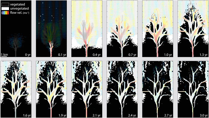 The coevolution of flow, vegetation and elevation during the first three years of a crevasse splay, a sedimentary fluvial deposit that forms when a stream breaks its natural or artificial levees and deposits sediment on a floodplain. Source: Florida State University
Wetlands are rapidly disappearing from coastal Louisiana: the loss is estimated to be equivalent to a football field each hour. Construction of levees along the Mississippi River has reduced inland flooding but also prevents sediment from reaching and accumulating on the coast to offset subsidence.
Engineers have been analyzing ways to make small cuts in the levees to allow for some of that sediment to flow through. A simulation tool based on the hydro‐ and morphodynamic model Delft3D developed at Florida State University and Tulane University will help planners optimize the placement and size of sediment diversions.
The model indicates that the effectiveness of sediment diversions vary depending on wetland characteristics. When determining the best way to build land in these at-risk areas, researchers or engineers could plug the relevant data into the model to sketch out potential outcomes.
The researchers said that engineers could potentially build 30 to 40 square kilometers of land within a few decades. However, in areas where there might not be as much vegetation or too much sediment or water is allowed in, the areas could wind up eroding more sediment and causing land loss instead of land gain.
The research is published in Geophysical Research Letters.