Pipeline Exposure Remediation Uses Erosion Control Methods
Celeste Roberts and Dan Hebert, PE | June 30, 2016In early 2014, a natural gas company sought a solution to a type of problem common among pipelines: the exposure of a 30-inch-diameter natural gas pipeline near a fast-moving river.
Located at the confluence of White River and the East Fork of the White River in Monroe City, Ind., the pipeline became exposed for approximately 80 linear feet due to lateral migration of the right-descending bank. From 2008 to 2014, the bank had eroded some 370 linear feet. The point of exposure became a receptacle for trees and debris, endangering the integrity of the pipeline.
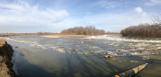 View of the site prior to construction in 2014. The natural gas company consulted Submar, a Houma, Louisiana-based erosion and sedimentation control company. In January 2014, Submar conducted a site survey to determine the nature of the erosion problem and to design a solution. A hydrographic survey was conducted in August 2014 to verify the riverbed contours for the design.
The river’s water elevation and swift current presented a construction challenge, meaning the project needed to be completed when the river’s gauge height was below five feet and during low discharge months (July through January). All stabilization work also needed to start and end in stable areas. The project limits and design were determined after critical analysis of the existing fluvial geomorphology observed in the field, river meander analysis of historic aerial photographs, and the vector analysis of flow attack into the project area.
 White River bank migration, 1998-2014. Completed in December 2015, the as-constructed design implemented a variety of erosion control methods: a pipeline span support, articulating concrete revetment mattresses, longitudinal peaked stone toe protection (LPSTP), bendway weirs, and vegetative plantings (live staking) with netless erosion control blanket to armor and protect the pipeline and stabilize the right-descending bank. The design was an alternative to lowering the line via horizontal directional drilling, a potentially invasive and costly alternative generally only used as a last resort.
Erosion Prevention Details
A pipeline span support with pilings was installed and clamped onto the pipeline before backfilling and armoring activities took place. The pipeline support system was installed to support the pipe from the horizontal and vertical loads.
The near-vertical bank was then graded to create a gentle, stable slope within the pipeline right-of-way, and large riprap was placed on the upstream and downstream side of the exposed pipeline. Angular filter stone and clean fill material were placed along the bed and the bank within the pipeline area.
A woven geotextile material was placed on the fresh grade, followed by the installation of a concrete mat system. The mats extended for roughly 160 linear feet from the right-descending high bank to the river bed. The mats were anchored into the high bank elevation in an excavated three-foot-deep termination trench. This was backfilled with riprap placed over the mat system in the river at a minimum overlap of four feet.
A revetment mat system was chosen to provide a long-term, continuous system of hard armor protection for the entire length of the pipeline from high bank to bed elevation. The mats are considered “engineered riprap” and, in comparison to riprap, generally perform much better in the streambed where the highest shear stresses occur.
The mats have a low hydraulic profile in the streambed at 4.5-inches thick, and can be removed and replaced for pipeline maintenance, if necessary. The mat system articulates and self-adjusts with the streambed to prevent the upstream migration of future head-cut erosion while allowing natural vegetation growth, restoring the look of a natural riparian corridor.
 White River bank migration, 1998-2014.An LPSTP system was then installed from a stable point upriver along the toe of the right-descending bank and extending for around 1,530 feet. LPSTP is used to protect the toe of the bank from erosive scour, which can lead to future lateral migration. LPSTP is a method of bank stabilization developed and used by the United States Army Corps of Engineers, and this technique works well where existing vegetation on the upper bank is in danger of being undermined and washed away by a migrating stream.
Rock or crushed concrete is mounded at the toe of the slope where the bank erosion process usually begins. The toe is held firm by the mass of rock. The upper bank above the rock vegetates and becomes stable due to the root systems holding the upper bank area. This method is encouraged by the Corps and the U.S. Fish and Wildlife Service due to the natural stream appearance and the creation of riparian habitat.
The upstream end of the LPSTP was keyed into the bank near the start of the bend. It was gently curved and keyed into the bank at approximately 20-30 degrees to create a smooth transition. The riprap was keyed into the riverbanks at its upstream and downstream limits with a maximum height of six feet. Three 90-foot keyways were placed up the banks in excavated trenches. The keyways were placed perpendicular to the flow of the river and tied back into the existing eroded bank to prevent water from flowing behind the LPSTP. Keyways help prevent flanking of the LPSTP if the stream begins to migrate.
Redirecting River Flow
Once the LPSTP was complete, eight bendway weirs were installed along the upstream section of the LPSTP system to redirect the high-velocity flow of the river. Bendway weirs are a form of bank stabilization, but are not a continuous method such as bank paving. This technology was developed and promoted by the Corps of Engineers and originally was a method to increase channel width in bends on the Mississippi River to improve navigation conditions and reduce maintenance requirements.
The redirection provided by the weirs stops the bank’s lateral migration and prevents the river from flanking the mats placed over the pipeline. The weirs are set up at intervals in the bend of the river. The spacing, length, and angle of the weirs depend on the curvature of the bend. The weir field is oriented to assist in moving the “thalweg”—the lowest point along the stream bed in a cross-sectional view and the highest velocities—away from the eroding bank.
Installation of the bendway weirs and the LPSTP is expected to provide a net benefit to local aquatic habitat by reducing high-flow velocities near the right-descending bank. This lower-velocity area serves as an area for smaller aquatic life to rest.
Live staking was planted on the bankline in order to anchor the soil once plant roots establish, creating vegetation roughness and promoting a wildlife environment. A netless erosion control blanket also was installed on the graded slope face to secure the manufactured soils at the completion of the project. The articulating concrete mattress system currently provides and maintains cover over the pipeline in the matted area. The combination of the LPSTP system and bendway weirs protects the toe of the right-descending high bank from future lateral migration.