
NASA Data Used to Track Groundwater in Pakistan
By Engineering360 News Desk | March 05, 2016University of Washington (UW) engineers and hydrologists are using NASA satellite data to help resource managers in Pakistan monitor and manage that country's water usage.
“Satellites up in space looking at how much water we have underground, in rivers or in the atmosphere, are providing routine observations that can help policymakers and on-the-ground managers make informed decisions,” says Faisal Hossain, UW associate professor of civil and environmental engineering. “From offering improved flood forecasting to indicating areas where groundwater resources are threatened, freely available satellite data can be an invaluable resource, particularly in developing countries.”
After training at UW, the Pakistan Council of Research in Water Resources in January 2016 began using satellite data from NASA’s Gravity Recovery and Climate Experiment (GRACE) mission to create monthly updates on groundwater storage changes in the Indus River basin. This will allow them to see where groundwater supplies are being depleted and where they are being adequately recharged.
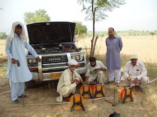 Pakistani water managers are accessing NASA satellite data to monitor groundwater changes. Image credit: Pakistan Council of Research in Water Resources.Like all NASA satellite data, GRACE data are freely available for download from open NASA data centers at the agency's Jet Propulsion Laboratory, in Pasadena, California.
GRACE’s pair of identical satellites, launched in 2002, map tiny variations in Earth’s gravity. Since water has mass, it affects these measurements. In this way, GRACE data can help scientists monitor where the water is and how it changes over time. Using tools developed by the UW and partners at the University of Houston; Ohio State University, Columbus; and NASA’s Applied Sciences Program, Pakistan’s water managers and researchers can analyze the NASA data to estimate changes in the total amount of available water, as well as changes in groundwater supplies.
“Using these satellites, we can indicate the areas that are most threatened by groundwater depletion. We can tell the farmers and water managers and help decision makers formulate better and more sustainable policies,” says Naveed Iqbal, assistant director and hydrogeologist at the Pakistan Council of Research in Water Resources. Iqbal spent six months at UW learning how to analyze and process the GRACE data to enhance decision making at his agency.
Compared to traditional groundwater monitoring efforts, the satellite information offers less spatial resolution but huge benefits in terms of cost and efficiency. Previously, Pakistani water managers spent eight years building a groundwater monitoring network in the Indus River basin that provides readings only twice a year.
“It’s so fundamentally difficult to do this monitoring in a conventional way—sending people and sticking probes in the ground to measure water. It takes a long time and it’s expensive,” says Hossain. “In some places you can’t even send people because the terrain is too remote or there is mortal danger due to insurgency and political strife.”
This project is one of a number that the UW team is carrying out to assist resource-poor nations in using satellite data to sustainably manage water and environmental resources. The team has helped Bangladesh better forecast and prepare for floods since 2014. In the coming months, the group will train resource managers from Vietnam to monitor water resources and land use change—as well as managers from Nepal to estimate water content in snowpack and glaciers in the Himalayas.