Particulate pollution estimation with satellites and neural networks
S. Himmelstein | April 28, 2020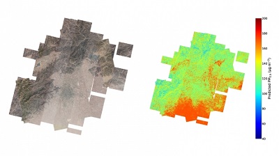 Detailed map of pollution levels in Beijing and surrounding areas based on a new machine learning algorithm for satellite images and weather. Source: Duke UniversityA lack of ground-based air quality monitoring stations and uncertainties inherent in available satellite data undermine the accurate determination of ground-level concentrations of 2.5 micrometer-diameter particulates (PM2.5). Duke University researchers have improved the accuracy of estimating ground-level PM2.5 with a computer vision algorithm designed to process micro-satellite imagery of spatial coverages significantly smaller than 1 km2.
The method was demonstrated for conditions in Beijing, China, using micro-satellite imagery with a 3 m/pixel resolution for a three-year period. A convolutional neural network with a random forest algorithm was applied to the images and combined with meteorological data from Beijing’s weather station. More than 10,000 satellite images were used to train the pollutant prediction model, which was then tested on another 2,622 images.
Ground-level PM2.5 was shown to be estimated accurately at a 200 m spatial resolution with a mean absolute error as low as 10.1 μg/m3, and to within 24% of actual PM2.5 levels measured at reference stations. Current standard practices can predict levels down to 1 million m2 while the new method is accurate down to 40,000 m2.
The research underscores the potential of augmenting existing spatial predictors of PM2.5 with high-resolution satellite imagery to enhance the spatial resolution of PM2.5 estimates for pollutant emission hotspot determination or particulate exposure assessment.