How Engineers Can Adapt Infrastructure Design for a Changing Climate
Winn Hardin | February 13, 2017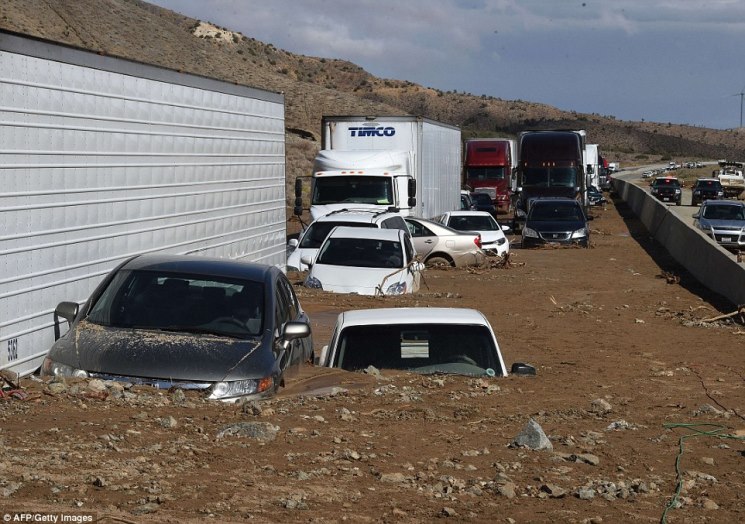 Mud flows on Oct. 15, 2015 shut a 30-mile stretch of I-5. Image source: Getty Images via Univ. of Arkansas
(Editor's note: In mid-February 2017, winter precipitation filled Lake Oroville north of California's capital, Sacramento, putting exceptional pressure on the Oroville Dam. The dam is a 770-foot-tall (230 meters) embankment dam that dates from 1968. The feared failure of the dam's spillway after a hole developed as water was being released prompted an evacuation order for 180,000 people downstream of the dam. In late 2015, Engineering360 published two articles that discussed possible risks caused by the state's ongoing drought and its sudden end. Republishing these articles is timely given the engineering challenges posed by the Oroville Dam.)
Now in its fourth year of severe drought, California is juggling with knives. Groundwater levels are falling. Seawater intrusion threatens drinking water supplies. Sinking land and erosion expose structural vulnerabilities. But drought alone does not cause infrastructure failure. Factor in heavy rainfalls or an earthquake, and that precarious knife-juggling act could result in some serious consequences.
(Read “Hardening the Infrastructure: Flood Management Controls.”)
California officials have put in place mandatory water restrictions and groundwater supplies are being recharged with clean-treated wastewater in southern parts of the state, but these efforts represent the proverbial drop in a bucket in mitigating drought risk and its impact on infrastructure.
The state’s volatile situation illustrates the challenges confronting civil engineers when planning infrastructure for drought and other extremes in the face of a changing climate. The primary challenge to the engineering community is developing strategies for the uncertainty that comes with projecting future climate conditions.
Cracks in the Facade
Prolonged periods of drought pose many threats, perhaps the biggest of which is the stability of levee systems. Droughts produce a series of weakening mechanisms that negatively impact the integrity of such earthen structures.
A leading source of stress on levees is land subsidence. Drought leads to increased extraction of groundwater from aquifers, which creates subsurface movement. Over time the land sinks or subsides.
 Farshid Vahedifard, Mississippi State UniversityExtensive groundwater pumping has exacerbated existing land subsidence in parts of the state, especially the Delta, says Farshid Vahedifard, an assistant professor at Mississippi State University. The geotechnical engineering specialist researches climate change and its impact on critical infrastructure performance. A climbing rate of soil organic carbon (SOC) decomposition due to drought also is contributing to land subsidence in the Delta.
Recent results from a monitoring program revealed that drought-accelerated land subsidence has reached as much as 2 inches per month in some places, several times greater than pre-drought subsidence rates.
Additional drought-induced stressors on levees include soil strength reduction, desiccation cracking, erosion, fissuring and soil softening, and increased SOC oxidation. In California, such conditions compound the stresses on levee systems that already are endangered, says Vahedifard.
High Hazard
The California Department of Water Resources evaluated the state’s levees in 2011 before the start of the current drought. The agency classified 51% and 55% of urban and non-urban levies, respectively, as high hazard. The designation indicates that levees are in danger of failing during an earthquake or flood.
The study results imply that functionality of the aging structures “will continue to decrease unless strategic actions are taken to implement some level of maintenance and rehabilitation approaches,” Vahedifard says.
That could spell disaster for the 13,000-plus miles of levees and their various functions should heavy rainfall or storm surges occur, a phenomenon that is not uncommon at the end of a drought. The Delta, for example, directs drinking water to 23 million people and irrigation water for several million acres of agriculture. Levees throughout most of the Delta downstream of Sacramento primarily protect land at or below sea level and often serve to hold water back.
Catastrophic failure of these non-urban levees could inundate land that has subsided below sea level “drawing in seawater and consequently contaminating the water supply,” Vahedifard says.
In comparison to the Delta’s levees, urban levees protect densely populated areas in the Central Valley and Northern California from flooding. According to Vahedifard, desiccation cracking “can be of greater consequence for the integrity of these intermittently loaded levees that may become completely dry during drought.”
Effects on Related infrastructure
Drought conditions impact more than levees. They can threaten any infrastructure interfacing with soil, including slopes, embankments, roads, bridges, building foundations and pipelines.
 Vincent Lee, ArupLand subsidence, for instance, puts utility connections at risk as buildings sink, says Vincent Lee, associate principal at the international engineering firm Arup. Canals and sewers are examples of utility conduits that require gravity to enable them to function properly, Lee says. “Sewer or drainage pipes tilting in the wrong direction would result in conveyance issues as water can’t flow uphill,” he says.
In California, two recent events demonstrate what heavy rains do to drought-stricken, soil-related infrastructure. An intense October storm with hail unleashed 300,000 cubic yards of mud and debris onto Interstate 5 and surrounding roadways north of Los Angeles. The mudslide trapped a few hundred vehicles.
In July, a bridge collapsed on Interstate 10 in the California desert between Los Angeles and Phoenix after flash flooding eroded the ground beneath the bridge supports. Repair of that magnitude can typically take 18 months; design engineers and construction crews finished the work in two months for $5 million.
To further complicate matters, the El Niño weather phenomenon is expected to hit California in early 2016 with the possibility of heavy rainfall and storm surges, adding stress to already vulnerable infrastructure.
In addition to heavy rain, extreme heat often accompanies drought. In the Southwest U.S. and Texas, extreme heat has caused railroad rails to bend, Arup’s Lee says. This increases the risk of train derailments. Meanwhile, decreasing water levels in rivers, channels and waterways can impact shipping and transportation routes. Power plants that rely on water for cooling may have to decrease their generation output or experience shutdowns. Low water levels on the Missouri River a decade ago impacted power generation across the Midwest.
Designing for Uncertainty
California’s drought-plagued infrastructure serves as a microcosm of the challenges that civil engineers face when adapting and designing critical infrastructure to be resilient to a changing climate.
 Bilal Ayyub, University of MarylandEngineers typically plan and design infrastructure according to historic weather records. With the changing climate, however, “the assumption that things are random but the same — that is, they are stationary — might not be valid,” says Bilal Ayyub, professor of civil and environmental engineering and the director of the Center for Technology and Systems Management at the University of Maryland. “We are dealing with a higher level of uncertainty in predicting extreme conditions compared to what we have done in the past.”
That uncertainty relates to the location, timing and magnitude of the changes over the lifetime of infrastructure. To help engineers navigate these unknowns, the American Society of Civil Engineers (ASCE) produced the white paper “Adapting Infrastructure and Civil Engineering Practice to a Changing Climate.”
Written by ASCE’s Committee on Adaptation to a Changing Climate, the paper identifies three types of information engineers need to effectively address climate change impacts: action-oriented knowledge, fundamental knowledge and analytical tools.
Civil engineers require action-oriented climate change information that characterizes climate projections over the next few decades. Also necessary is understanding interdependencies within and between the various components of civil infrastructure.
Fundamental knowledge involves re-examining many civil engineering design standards and performance metrics. That means everything from identifying limits in current designs and materials for extreme loads to evaluating the effects of changing demands on infrastructure vulnerabilities.
Analytical methods are necessary to integrate variance into planning and design, measure the effectiveness of infrastructure adaptation and define and evaluate the economic implications of infrastructure vulnerabilities.
Ayyub also points out that designing with climate change in mind necessitates a risk-management strategy that allows a system to be updated as conditions change. This framework includes monitoring various infrastructure components with sensors to detect early warnings of stress, says Ayyub, a lead author on the ASCE paper. Performance data collected over the years can yield insights into a system’s performance under changing conditions.
In addition to the paper, ASCE’s Infrastructure Resilience Division generated a list of potential initiatives this past summer that address how to implement resilience concepts for infrastructure into civil engineering practice.
 Amir AghaKouchak, University of California at IrvineOne roadblock awaiting engineers is that the codes used to design infrastructure don’t necessarily consider drought. “When the engineering community built all of this infrastructure in the 1940s and ’50s, potential impacts of droughts were unknown,” says Amir AghaKouchak, a hydrologist and assistant professor at the University of California, Irvine.
Updating the codes is a complicated process that requires research not only to understand the mechanisms but also develop methods and frameworks to factor drought conditions into designs.
“There are infinitely potential ways to make a structure stable, but those ideas should be explored and calculated by the greater scientific community,” AghaKouchak says.
Putting Infrastructure to the Test
Research, development and demonstration will help civil engineers address the impact of climate change on the infrastructure they design. In his work on quantitatively assessing the resilience and vulnerability of critical infrastructure to extreme events under a changing climate, Mississippi State’s Vahedifard is collaborating with hydrologists and climate scientists to bridge the gap between climate science and engineering practice.
One part of his research assesses the thermo-hydro-mechanical impacts of climate change on the performance of and soil-structure interaction in critical earth structures. In another part, Vahedifard and his colleagues are working to develop tangible design and risk management approaches for critical infrastructure.
The research team currently is evaluating the effects of California’s drought on soil strength and the structural integrity of the state’s levee systems, as well as the effects of increased rainfall intensity on landslide activities in Seattle, Wash.
At UC Irvine’s Center for Hydrology & Remote Sensing, AghaKouchak has developed the Global Integrated Drought Monitoring and Prediction System (GIDMaPS). The system relies on NASA data products to generate meteorological, agricultural and agro-meteorological drought information. AghaKouchak and his team will soon unveil a fourth category based on relative humidity. He expects that to help detect drought onset earlier than other indicators.
Used for seasonal analysis, the statistical drought prediction model estimates how drought will change in the next 4 to 6 months. “We don’t go any farther out into the future because drought prediction is very challenging,” AghaKouchak says. He and the other researchers also are developing a California-specific model.
Solutions for a more resilient infrastructure are starting to emerge outside the lab. “We need a systematic approach and understanding of how one system affects another,” Lee says. “Engineering solutions need to be tied to an elegant and integrated design.”
Lee cites the proposed reconfiguration of the 51-mile Los Angeles River corridor. Project planners and engineers seek to integrate design and infrastructure for a “more aesthetic solution that benefits the community while still functioning from an engineering standpoint,” Lee says.
The Los Angeles River Revitalization Corp. has commissioned architect Frank Gehry and a team of experts to analyze data and recommend river interventions and capital improvements “based on design storm impacts and process methodology.”
The initial study, which involves public engagement, will address factors such as flood management, infrastructure resilience, recreation and quality of life. Lee says that public engagement in this and other infrastructure projects is critical. After all, “many communities may have to transform significantly as climate change risks increase.”